Stunning footage has provided a new view of the world's largest iceberg, as it begins its journey to the Southern Ocean.
The iceberg, called A23a, has an area of about 1,540 square miles and is 1,312 feet thick.
It made headlines last week when it began to move, after 30 years at the bottom of the ocean.
Now, the British Antarctic Survey (BAS) has released new video and photos taken by the RRS Sir David Attenborough ship.
Dr Andrew Myers, Chief Scientist at RRS Sir David Attenborough and Head of Polar Oceanography at BAS, said: “It is fortunate that the iceberg’s path out of the Weddell Sea lies directly across the planned path, and that we have the right team on board to take advantage of this opportunity.” .
While A23a originally broke off from the Filchner Ice Shelf in 1986, it remained anchored to the seafloor until last week.
On November 24, the giant mountain broke free and began moving out of the Weddell Sea sector into the Southern Ocean.
Now, the massive mountain is likely to be swept away by the Antarctic current into an "iceberg pool," according to BAS.
Aside from photographing it, the researchers also took samples from the iceberg, hoping it will aid our understanding of how climate change will affect the Southern Ocean and the organisms that live there.
“We know that these giant icebergs can provide nutrients to the water that passes through them, creating thriving ecosystems in less productive areas,” said Laura Taylor, a biogeochemist working on the mission.
Rising water and air temperatures caused by global warming are causing instability along the coasts of Antarctica and Greenland, accelerating the melting of ice.
Scientific magazine: An ancient waterway linking the pyramids of Egypt can be viewed from space
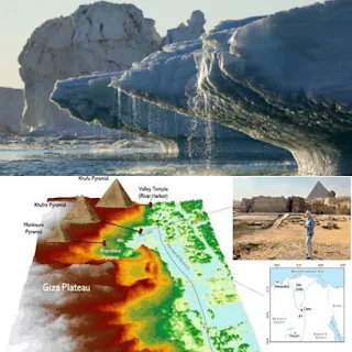
Scientists will be able to solve the mystery of the construction of the Egyptian pyramids by discovering the bottom of the ancient Nile River. This was reported by the scientific journal IFLScience.
The branch of the Nile River previously passed through the Giza area, but it dried up completely. Dr. Iman Ghoneim, a specialist in remote Earth sensing in the United States, was able to discover the arms of the ancient Nile, using data received from a radar satellite to study the Nile valleys from space. Space radar data revealed a hidden, invisible world of information hiding beneath the Earth's surface.
It showed the long-dried bed of the Nile River, whose channels meandered through the desert, in radar images. Its length reached 100 kilometers.
Ghoneim said: “The length of the canals was not only great, but their width was also great. We are talking about half a kilometer or more, which is equivalent to the width of the main canal of the Nile River today.”
The now-vanished waterway ran from Fayoum to Giza and passed through 38 remaining pyramids. Therefore, it was called the “Pyramids Branch.” The team of scientists now wants to analyze soil samples to determine whether these arms existed in the era of the Old and Middle Kingdoms (3,700 to 4,700 years ago) when the pyramids were built.
Ghoneim believes that there were ports near most of the pyramids in those distant times. The Nile's streams extended to most of the temples in the valley.
She added, "As river courses changed, Egyptian cities also disappeared. To this day we have no idea where to look for them. But discovering ancient river courses will help discover them."
It is known that radar waves penetrate the ground and help illuminate dry riverbeds that extend across the desert and agricultural lands. The non-existent waterway passed through dozens of pyramids, starting from Fayoum and ending in Giza. Scientists will soon analyze soil samples from the ancient river bed.


Larger than the largest.
ReplyDelete